ePrivacy and GPDR Cookie Consent management by TermsFeed Privacy Policy and Consent Generator PR TF 43.5 Arenas Negras Loop Trail

PR TF 43.5 Arenas Negras Loop Trail

PR-TF 43.5

Altos de Garachico

Difficulty: Low

Description

This branch of the PR TF 43 trail takes you on an easy walk around the famous Arenas Negras Volcano in Tenerife.

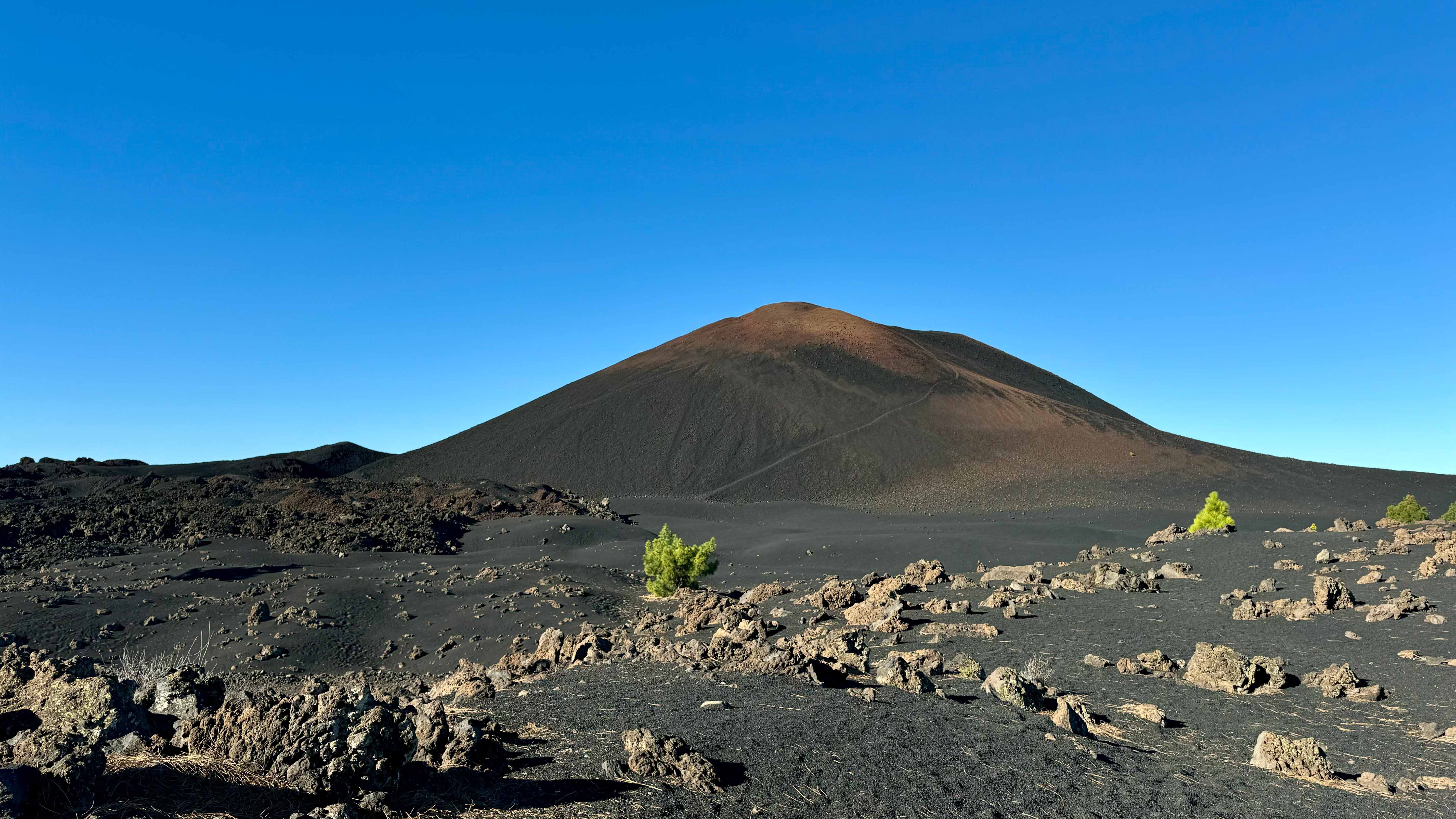
Also known as Volcán de Garachico, this volcano was formed by one of the most recent eruptions on the island in 1706. The volcano takes its other name from the town of Garachico, the trading capital of Tenerife at the time, which was destroyed by the eruption.

The route starts from the Arenas Negras Recreational Area and can be followed in either direction, each as beautiful as the other.

The trail itself is very manageable and mostly follows well-marked paths. However, please note that there are some rocky sections of malpais (lava fields), and we recommend that you take special care when crossing them.

During the walk you will be surrounded by a magical landscape that combines the characteristic tephra deposits and black lava flows of the volcano with lush green pine forests.

This route is a great way to explore and appreciate the natural beauty and geological history of the area. In addition, the Arenas Negras Recreational Area is an ideal place to rest and have a picnic before or after your hike.

Tips

  • Always stay on the marked trail and do not enter private property, hunting grounds, water galleries, wells or caves. 
  • Pay special attention when crossing or walking along trails used by bicycles, horses or motor vehicles and when walking in ravines with water courses.
  • Avoid direct encounters with potentially dangerous animals, such as livestock, beehives, and dogs.
  • Proceed with caution and watch for obstacles, loose rocks, uneven terrain or steep slopes to avoid accidents and falls.
  • Check out our guide to hiking in Tenerife and, if necessary, contact the emergency services by calling 112.
Recommendations and tips

Guides

No data available

Permits

  • [TEMPORARY MEASURE] Free access without authorisation or reservation for natural or legal entities of a public or private nature, both non-profit (town councils, schools, associations, clubs, etc.) and for-profit (active tourism companies), until 31 December 2024 as established in the Resolution.
  • Free access for all other visitors, no reservation required.
  • Email for enquiries - This email address is being protected from spambots. You need JavaScript enabled to view it.
More information

Technical information sheet

Route information

Walking route

Tenerife ON

Circular

11,66 km

1 h 55 m *

Check your fitness level

  • Altitude gain:486,92 m

  • Altitude loss:486,92 m

  • Maximum altitude:1.389,46 m

  • Minimum altitude:1.225,76 m

Signage

Route code

PR-TF 43.5

Posts and signs displaying the PR code and yellow and white marks.

Signage

Route map and profile

Elevation profile

Difficulty

Low *MIDE safe mountain criteria

  • Maximum altitude:1.389,46 m

  • Minimum altitude:1.225,76 m

Connections with other routes

  • /

How to get to route start point

Arenas Negras Recreational Area, Pista General Arenas Negras – Garachico.

No public transport service in the area.

Very limited parking spaces in the Recreational Area.

How to get to route end point

Arenas Negras Recreational Area, Pista General Arenas Negras – Garachico.

No public transport service in the area.

Very limited parking spaces in the Recreational Area.

Municipalities passed through

  • El Tanque
  • Garachico

Protected Areas

Transit

Reserva Natural Especial del Chinyero

The Chinyero Special Nature Reserve is located on the Abeque ridge, one of the three volcanic rifts on the island and the most active at present. Two historical eruptions have taken place here: ...

Discover the Protected Area
Reserva Natural Especial del Chinyero

Transit

Parque Natural de la Corona Forestal

The Corona Forestal is the largest protected natural area in the Canary Islands, one of the most extensive forests on the islands, the lungs of Tenerife and the gateway to Mount Teide.  As its name ...

Discover the Protected Area
Parque Natural de Corona Forestal

Weather

Today, wednesday, in El Tanque


Clouds
Wind

1 km/h

Temperature

22ºC Maximum

20ºC Minimum

Rain

371%

3 day forecast

thursday

22ºC Maximum

19ºC Minimum

friday

23ºC Maximum

17ºC Minimum

saturday

23ºC Maximum

18ºC Minimum

Places of interest

These are some of the points of interest you can find along this route.

Pino_Donde_El_Buey_Hablo
Monumental tree

Pine tree at the place where the Ox spoke

It is said that a team of oxen was hauling wood along the track when one ox fell, exhausted, to...