ePrivacy and GPDR Cookie Consent management by TermsFeed Privacy Policy and Consent Generator El Palmar – Baracán via Teno Alto

El Palmar – Baracán via Teno Alto

Macizo de Teno

Difficulty: High

Description

This demanding hike gives visitors a complete experience of Teno Rural Park, crossing a wide variety of landscapes along the way: old, cobbled paths, panoramic views of Palmar Valley, where agriculture takes pride of place, the hamlet of Teno Alto, with its livestock farming tradition, and the spectacular scenery of Baracán.

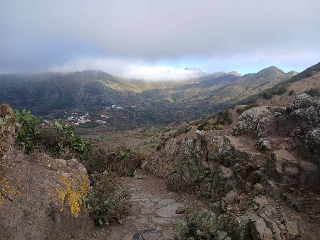
The route starts at Los Pedregales Visitor Centre, and from there it heads west along Callejón de Teno, an old stone-paved camino real (“royal road” or main island route), which begins with a steep ascent to Altos de la Cumbre. It then enters the laurel forest and gradually changes to a crop and livestock farming landscape until it reaches Teno Alto, where living tradition and nature come together as a result of the isolation and remoteness of this place.

The picturesque village of Teno Alto retains the charm of traditional Canarian settlements, with stone houses and landscapes transformed by the human need to farm and raise livestock. Here you can also sample the local produce.

From here, take Camino a La Mesita, which offers impressive panoramic views of the summit of Baracán and leads to the famous Baracán viewpoint. There, at the crossroads, leave the PR-TF 51 trail and take the Las Tabaibas shortcut on the left, which descends gently to the road in the vicinity of Segovia.

At this point we recommend that you pay special attention when crossing the main road before taking the PR-TF 52.2 trail, which will take you back to the starting point.

Tips

  • Always stay on the marked trail and do not enter private property, hunting grounds, water galleries, wells or caves.  
  • Pay special attention when crossing or walking along trails used by bicycles, horses or motor vehicles and when walking in ravines with water courses.
  • Avoid direct encounters with potentially dangerous animals, such as livestock, beehives, and dogs.
  • Proceed with caution and watch for obstacles, loose rocks, uneven terrain or steep slopes to avoid accidents and falls.
  • Check out our guide to hiking in Tenerife and, if necessary, contact the emergency services by calling 112.
Recommendations and tips

Guides

No data available

Permits

  • [TEMPORARY MEASURE] Free access without authorisation or reservation for natural or legal entities of a public or private nature, both non-profit (town councils, schools, associations, clubs, etc.) and for-profit (active tourism companies), until 31 December 2024 as established in the Resolution.
  • Free access for all other visitors, no reservation required.
  • Email for enquiries - This email address is being protected from spambots. You need JavaScript enabled to view it.
More information

Technical information sheet

Route information

Walking route

Tenerife ON

Circular

9,66 km

3 h 20 m *

Check your fitness level

  • Altitude gain:775,52 m

  • Altitude loss:775,52 m

  • Maximum altitude:974,76 m

  • Minimum altitude:530,36 m

Signage

Route coinciding with the signposting of trails PR TF 57 and PR TF 51 up to Baracán. The section between Baracán and El Palmar is not signposted, but the trail is perfectly visible.

Signage

Route map and profile

Elevation profile

Difficulty

High *MIDE safe mountain criteria

  • Maximum altitude:974,76 m

  • Minimum altitude:530,36 m

Connections with other routes

How to get to route start point

Los Pedregales Visitor Centre, Teno Rural Park, Carretera Buenavista (TF-436), km 6.

Bus numbers 355, 365 and 366, Las Canales bus stop code 4546. TITSA

Parking spaces available in the urban area and at the Visitor Centre.

How to get to route end point

Los Pedregales Visitor Centre, Teno Rural Park, Carretera Buenavista (TF-436), km 6.

Bus numbers 355, 365 and 366, Las Canales bus stop code 4546. TITSA

Parking spaces available in the urban area and at the Visitor Centre.

Municipalities passed through

  • Buenavista del Norte

Protected Areas

Transit

Parque Rural de Teno

Teno Rural Park is located in north-west Tenerife, in one of the first parts of the island to emerge from the sea, containing materials that are between 6 and 7 million years old.  Erosion has ...

Discover the Protected Area
Parque Rural de Teno

Weather

Today, wednesday, in Buenavista del Norte


Clouds
Wind

3 km/h

Temperature

24ºC Maximum

23ºC Minimum

Rain

271%

3 day forecast

thursday

24ºC Maximum

23ºC Minimum

friday

24ºC Maximum

22ºC Minimum

saturday

24ºC Maximum

22ºC Minimum

Places of interest

These are some of the points of interest you can find along this route.

Pico_Baracan
Rock

Pico Baracán

Peak located 1,000 metres above sea level, separating El Palmar valley and the ravine known as...

Mercadillo del Agricultor El Palmar
Unique building

El Palmar Farmers’ Market

Local farm, handicraft and organic products for sale.

...
Unique building

Teno Alto Chapel

Small chapel in front of the village square, amongst farmed terraces and pastures.

...
Teno Alto
Hamlet

Los Bailaderos or Teno Alto

This stronghold of the island’s rural customs lies in the heart of Teno Rural Park. It boasts a...